Geo-Tagging allows photographers to embed the details of the physical location (latitude/longtitude) from where the photo is taken. This information is usually recorded as EXIF (Exchangeable Image File) data inside the photograph.
How is geo-tagging useful?. Well, in the first place, you will be able to identify the exact location each photo was taken. Imagine being able to go back to the exact same location after 20 years and compare the scene from the original photograph. For historians, it can provide vital information on changing environment.
Most professional digital cameras can link to an external GPS unit and automatically embed the location information everytime a photo is taken.
But what about normal digital cameras that cannot record this information?. One low-tech solution is to use a stand-along GPS unit such as the SONY GPS-CS1. Just make sure the date and time on the camera is synchronized with the GPS unit and the included software will then scan your images to match the date/time with the coordinates recorded by the GPS unit.
If you have your own GPS unit, you could also record geo-tags in your images manually using an EXIF editor tool such as the Opanda Exif Editor.
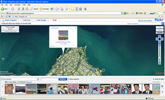
But this article is not about all of the above. It is about how href="http://www.flickr.com/">Flickr has come out with a cool way of embedding geo-tags inside your photos - and the good thing is that you don't need any hardware or software to do it!
By integrating Yahoo! maps inside the Flickr photostream, users can zoom into the map to identify the spot at which the photo was taken - and simply drop the photo at that location.
Flickr automatically reads the physical coordinates and embeds them inside your photograph. Once you have geo-tagged all your photos, you can view a global map showing the locations where each photo was taken. Pretty cool!.
I have just started geo-tagging my photos. You can see an example here.
Now for the not so cool part. Yahoo! maps are'nt the best in the world (At least when compared to Google maps). Yahoo! maps are pretty detailed for the U.S. region, but fall short when it comes to the rest of the world. It would have been really cool if Flickr had integrated their
service with Google maps, but I guess that would be asking too much since Flickr is owned by Yahoo!. I only hope Yahoo! updates it's maps to be on a similar level as Google.
Secondly, Geo-tagging using satellite maps can be, at most, a task in approximation (however detailed the maps may be or may become in future). It can never replace a direct interface between the camera and a GPS unit. But in the absence of a GPS interface, it is the next best thing.
Go ahead and try it out.
1 comment:
I will defiantly try it, great article.
Post a Comment